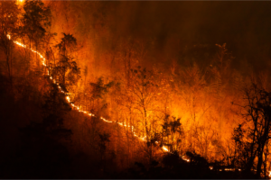
As global concern over climate change grows, drought has become one of the challenges facing Indonesia, which experiences a dry season every year. Although it is a normal climate cycle, if the dry season is prolonged, it can increase the risk of drought in various regions. The situation becomes even more challenging during extreme climate events such as El-Nino, which can reduce rainfall.
El-Nino can reduce the formation of rain clouds so that conditions become drier. Until the middle of 2026, El-Nino conditions were intensifying, especially during May, June, and July. The Indonesian Agency for Meteorology, Climatology, and Geophysics (BMKG) predicts that El-Nino conditions will persist through the first quarter of 2027, with peak intensity reaching above the strong category, impacting on reduced rainfall in parts of the region. These conditions are reflected in a dry season that is predicted to be longer than normal, covering 437 Climate Season Zones (ZOM), or 48.77% of Indonesia’s land area.
The combination of El-Nino and the dry season will cause drought and reduce the moisture level of vegetation. With drier conditions met with fire-prone areas will increase the potential for forest fires and land. Based on data from the Ministry of Forestry, forest and land fires in Indonesia from January to July 2026 reached 202.010,96 hectares.
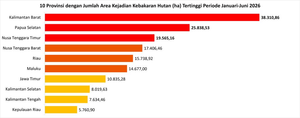
The number of fire incidents during this period increased, surpassing the number of forest and land fires recorded in 2019 and 2023 in the same period and also which also coincided with El-Nino events. The intensity of El-Nino that takes place in mid–2026, especially in the May-July period, is indicated by the value of the Oceanic Nino Index (ONI) which reaches 1,4 °C. This value is higher than the value of ONI in the entire period of 2019. In addition, different from 2023, strong intensity only appeared at the end of the year, El-Nino conditions in 2026 actually entered moderate levels earlier. As reported by Kompas.com, the head of BMKG, Teuku Faisal Fathani, explained that the 2026 El-Nino comes faster than the normal four-year cycle due to climate anomalies and the impact of global climate change. This condition is one of the factors causing the threat of forest and land fires this year relatively faster.
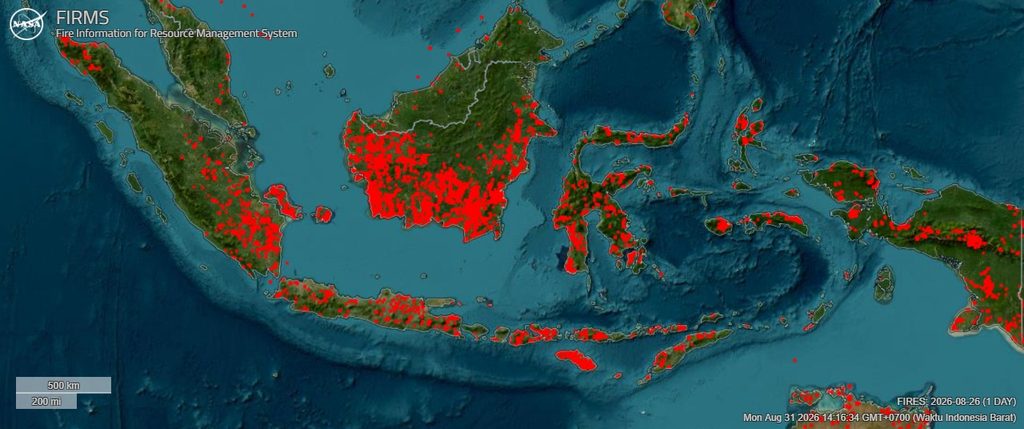
According to data from the Ministry of Forestry, monitoring by NASA’s Fire Information for Resource Management System (FIRMS) as of August 26, 2026, detected hotspots across several parts of Indonesia. The hotspots were widely distributed, particularly across Kalimantan, East and West Nusa Tenggara, Sulawesi, southern Sumatra, and eastern Java.
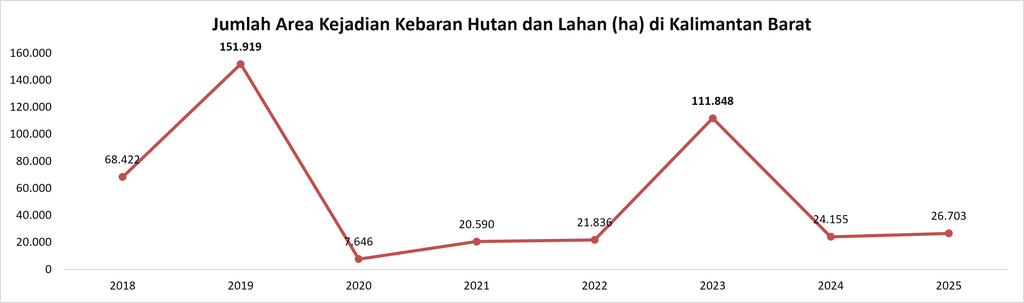
West Kalimantan province, which is the region with the largest area of forest and land fires in 2026 reaching 38.310,86 hectares. Historically in the period 2018-2025 almost every year experienced forest and land fires. The worst cases recorded in the last eight years occurred in 2019 and in 2023. Forest and land fires are also associated with landscapes where soil characteristics increase vulnerability to fire. Around 4,5 million hectares of land in Kalimantan consist of peatland (Pantau Gambut 2026). However, land-use conversion and the construction of drainage channels around these areas lower the water table. As a result, the drying and oxidation of organic matter occurs more quickly, making peat highly susceptible to fire under dry conditions. Therefore, the effectiveness of mitigation efforts and land management will be key to limiting the spread and duration of fires.
In the end, forest and land fires during the dry season are not simply natural disasters. They are a real consequence of climate change, exacerbated by inadequate land management. Maintaining peat moisture and strengthening preparedness in vulnerable areas is a crucial step so that the threat of drought does not lead to a more severe environmental crisis.
References:
Dian I. 2026. Karhutla Indonesia 2026: Mengapa Luas Kebakaran Melonjak pada Juli Hingga Agustus?. https://www.suara.com/news/2026/08/25/131500/karhutla-indonesia-2026-mengapa-luas-kebakaran-melonjak-pada-juli-hingga-agustus.
Direktorat Pengendalian Kebakaran Hutan, Kementerian Kehutanan. (2026). Indikasi luas kebakaran. SiPongi+ Sistem Pemantauan Karhutla. https://sipongi.gakkum.kehutanan.go.id/indikasi-luas-kebakaran.
Ginting FI, Fiantis D. (2026). Karhutla Kalimantan adalah drama berulang akibat kegagalan kita melindungi tanah. The Conversation. https://theconversation.com/karhutla-kalimantan-adalah-drama-berulang-akibat-kegagalan-kita-melindungi-tanah-290304.
NASA FIRMS. (2026). Fire Information for Resource Management System (FIRMS). National Aeronautics and Space Administration. https://firms.modaps.eosdis.nasa.gov/map/.
NOAA Climate Prediction Center. Oceanic Niño Index (ONI):
Historical El Niño / La Niña episodes (1950–Present). (2026). https://www.cpc.ncep.noaa.gov/products/analysis_monitoring/enso/oni/v6/.
Pantau Gambut. (2026). Peta gambaran umum: Sebaran gambut di Indonesia. https://pantaugambut.id/peta-gambut/.
Priyambodo U, Ade S. 2026. Indonesia Membara: Mengapa Kebakaran Hutan Terus Berulang?. https://nationalgeographic.grid.id/read/134406249/indonesia-membara-mengapa-kebakaran-hutan-terus-berulang?page=all.
Prasetyaningtyas K. (2026). https://www.bmkg.go.id/iklim/prediksi-musim/prediksi-musim-kemarau-tahun-2026-di-indonesia.
Wiryono S. 2026. BMKG Ungkap Penyebab El Nino 2026 Datang Lebih Cepat dan Berpotensi Sangat Kuat. https://nasional.kompas.com/read/2026/08/05/07380091/bmkg-ungkap-penyebab-el-nino-2026-datang-lebih-cepat-dan-berpotensi-sangat.
Zahro AA. (2026). Musim Kemarau di bawah Normal dan El Niño Kuat, BMKG Gencarkan Modifikasi Cuaca dan dukung Mitigasi Lintas Sektor. https://www.bmkg.go.id/siaran-pers/musim-kemarau-di-bawah-normal-dan-el-nino-kuat-bmkg-gencarkan-modifikasi-cuaca-dan-dukung-mitigasi-lintas-sektor.