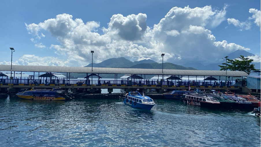
December 2025, our journey began in the early hours of the morning, as we headed east towards Indonesia. North Maluku was our destination, a province with a history closely linked to spices and global trade routes. Ternate, often referred to as the “City of Spices,” was our gateway before continuing our journey to Sofifi, the capital of North Maluku Province, located in the Tidore Islands. This visit was part of a series of field validations for the Academic Study for Enhancing Climate Resilience and Action project, which examines climate resilience development in four priority sectors: Marine and Coastal, Water, Agriculture, and Health.
In the field, flooding is a strategic issue in the water sector and is a common thread linking residents’ stories with technical findings. Flooding is no longer perceived as a seasonal event, but has become part of everyday life for communities in both Ternate and Sofifi. Residents say that heavy rains almost always result in flooding.
Guraping Subdistrict, North Oba District, is one of our focus areas. Initial observations downstream indicate significant silting. The riverbed appears shallow and filled with sediment, greatly limiting its capacity to accommodate water discharge. This explains why even relatively short periods of rain often trigger flooding. The local subdistrict head said that almost every rainfall is followed by flooding. In areas that are more severely affected, such as Toburo Hamlet in Kusu Village, just one hour of heavy rain is enough to cause flooding as high as an average adult’s chest.

To trace the main sources of sedimentation that trigger flooding, a simple preliminary spatial analysis was conducted using Google Maps imagery during field observations. From this investigation, a fairly large open area was identified in the upper reaches of the Ake Toburo River, Guraping. This finding is an initial indication that land cover degradation in the upper reaches has the strong potential to contribute to increased sediment accumulation in the lower reaches of the river.
Gabions have been installed along the riverbanks as a safety measure. However, they have not been fully effective because they do not address the root of the problem. The main source of the problem is not solely the erosion of the riverbanks downstream, but rather the continuous supply of sediment that arrives every time it rains.
To trace the main sources of sedimentation that trigger flooding, a simple preliminary spatial analysis was conducted using Google Maps imagery during field observations. From this investigation, a fairly large open area was identified in the upper reaches of the Ake Toburo River, Guraping. This finding is an initial indication that land cover degradation in the upper reaches has the strong potential to contribute to increased sediment accumulation in the lower reaches of the river.
Gabions have been constructed along the riverbanks as a protective measure. However, they have not been fully effective because they do not address the root of the problem. The main source of the problem is not solely the erosion of the riverbanks downstream, but rather the continuous supply of sediment that arrives every time it rains.
After returning from North Maluku, together with the Bhumi Pasa Hijau team, I continued a more in-depth spatial analysis using multitemporal remote sensing data, specifically Sentinel-2A imagery. The results of the land cover change analysis showed significant dynamics. In 2017, the upper reaches of the Ake Toburo River were still dominated by dense vegetation that functioned optimally in retaining rainwater and reducing surface runoff. This condition was reflected in the visualization of the images, which were still homogeneous and green in color.
However, noticeable changes began to occur in 2018, when large-scale land clearing was identified in the upper reaches. The loss of vegetation cover resulted in drastic changes in the hydrological response of the watershed. Rainwater, which was previously retained and absorbed into the soil, now flows directly on the surface as runoff. As a result, the flow energy increased sharply and began to erode the surface soil massively.
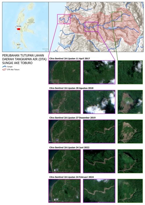
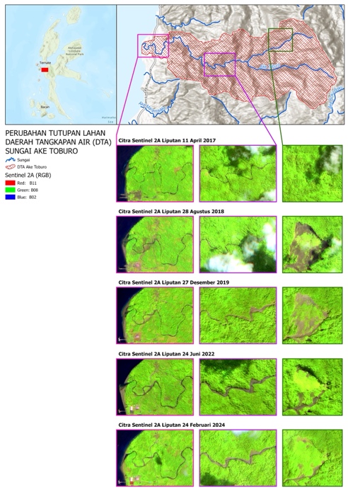
Land Cover Change in the Ake Toburo River Catchment Area, Guraping Village, North Maluku
Combination of natural color band (4-3-2) and agriculture band (12-8-2) from Sentinel 2A Copernicus satellite imagery
The continued impact of this process was clearly visible in the following years. Satellite imagery from 2022 shows that the Ake Toburo River basin and surrounding areas began to appear increasingly exposed. The riverbanks, which were previously covered with vegetation, slowly eroded. This condition was most likely triggered by a combination of increased water discharge during heavy rains and the supply of sediment material from upstream. The discharge exceeded the river’s natural capacity, causing lateral erosion, widening the river channel, and damaging the stability of the banks.
This degradation process occurs repeatedly and accumulates from year to year. By the 2022–2024 period, the riverbed appears to be evenly exposed along the entire flow path, indicating that the river system has lost its natural ability to stabilize itself. Erosion and landslide material from upstream continues to be transported and eventually deposited in the middle to downstream sections of the river. This accumulation of sediment causes siltation, reducing the river’s capacity and directly increasing the risk of flooding during rainfall.
Although in 2024 vegetation cover in the upstream area began to show signs of recovery, the damage that had occurred to the riverbed did not immediately recover. Suboptimal land cover conditions continue to trigger erosion and landslides, especially during extreme rainfall events, which are becoming more frequent due to climate change. Without comprehensive, ecosystem-based watershed restoration efforts, this cycle of erosion and sedimentation will continue to repeat itself, placing downstream areas at chronic risk of flooding.
The impact of flooding is not limited to inundation alone. Repeated flooding also hits the agricultural sector and the economy of the residents. Most of the people of Guraping and its surroundings depend on coconut and nutmeg farming for their livelihoods. Flooding causes crop failure, disrupts production activities, and weakens household economic resilience.
Historical activities have contributed to the current environmental conditions. Local residents mentioned that logging activities by a timber company had previously taken place in the upstream area. Although these activities have ceased, the impact of land degradation is still felt today, particularly in the form of landslides and sedimentation that have not been fully addressed. However, based on spatial analysis, large-scale land clearing is suspected to be related to mining activities, which further accelerate land cover degradation.
Mr. WS, Head of Toburo Hamlet, revealed that the relevant agency had dredged the river as a mitigation measure. However, this measure has not yet yielded sustainable results, as sedimentation has returned within a relatively short period of time. Flood management in Guraping and its surroundings requires cross-organizational cooperation among regional agencies, ranging from forest and national park managers, the River Basin Agency, the Public Works Agency, to the village government. Land cover restoration through reforestation in the upstream area, accompanied by periodic dredging of sedimentation in the downstream area, is a recommended measure that needs to be implemented consistently.
From Sofifi, this story reminds us that physical infrastructure alone is not enough to address climate challenges and environmental degradation. Without ecosystem restoration in upstream areas and river basins, and without strong institutional coordination, levees and gabions will only serve as silent witnesses to recurring floods.